-
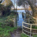
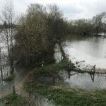
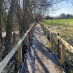 Ewen 2.5 miles
Update 18/3/26: All clear. Photo current.
-
 Water Hay 8 miles
Update 18/3/26: All clear.
-
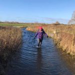
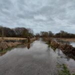
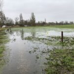
 Field before North Meadow 11 miles
The field between the disused railway and North Meadow may be be flooded. If so, you can avoid this by following the disused railway (cycle route 45) into Cricklade. Photo not current. Update: 8/4/26: all clear
-
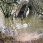
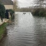
 Cricklade A419 Underpass 12 miles
Update 18/3/26: All clear albeit a little muddy! Photo current.
-
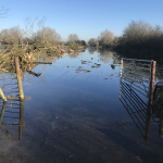
 Cricklade to Castle Eaton 14-16 miles
The approach to Castle Eaton is dry. There may be isolated pockets of dampness between Cricklade and Castle Eaton but nothing significant. Photo not current.
-
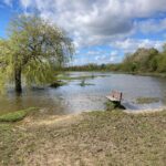
 Shifford Lock 37 miles
Update 18/3/26: Likely to be all clear. Photo not current.
-
 Newbridge 39 miles
Update 18/3/26: All clear. Photo not current.
-
 Bablock Hythe 43 miles
Update 18/3/26: All clear. Photo not current.
-
 Clifton Hampden 68 miles
Path both downstream from Clifton Hampden a little wet underfoot. Upstream and downstream seems to be clear. Photo not current.
-
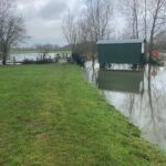
 Shillingford 73 miles
Path from Shillingford to Shillingford Bridge heavily flooded. Update 24/2. Update 11/3/26: Now clear.
-
 Cholsey Meadows 78 miles
Update 24/2. Heavy flooding. Consider following Ridgeway alternative and utilise parallel paths/roads away from the river. Update 11/3/26: Now clear. Photo not current.
-
 Goring 82 miles
Update 24/2: Path flooded between Goring and Gatehampton. Photo not current. Update 11/3/26: Now clear.
-
 Shiplake 101 miles
Update 20/3. Now clear. Photo not current.
-
 Spade Oak 115 miles
Update 20/3. Now clear. Photo not current.