-
 Osney Bridge 53 miles
As you approach Osney Bridge in a downstream direction, the towpath is closed about 150 yards from the bridge. A diversion sign takes you parallel to the river along Abbey Road. When you reach Botley Road, turn right and you will get back to Osney Bridge.
-
 Abingdon 62 miles
As you approach Abingdon in a downstream direction, the Path switches from the right bank to the left bank via a walkway across the weir. Due to corrosion, this walkway has been closed and the Path re-routed via Abingdon town centre. Note that if the river level is low the weir may be re-opened. But it will close again once the river levels rise.
-
 Benson 74 miles
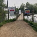
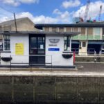
The weir, above which the Thames Path crosses the river, was damaged in 2022 and is currently being repaired. A diversion is in place mostly using minor roads through Preston Crowmarsh and Howbery Business Park, crossing the river at Wallingford Bridge. A shuttle ferry service is available from Benson Marina to the lock. However, this is now only operating at weekends between 10am and 4pm and is subject to river conditions. If in doubt, call them on 07375 677823. UPDATE: 1/4/26. Today the path was re-opened.
-
 Goring 82 miles
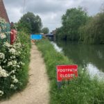
Immediately downstream of the bridge at Goring the Path is closed for about 1/4 mile with a small diversion. This takes you onto the parallel Manor Road and a footpath will take you back to the river
-
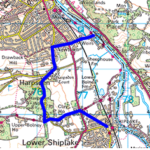 Shiplake to Henley 101-105 miles
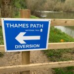
The boardwalk is closed upstream of the lock. The diversion previously in place has been removed. A new diversion has been put in place which includes some road walking but on quiet country lanes. It also involves an additional 1 mile of walking. Do not be tempted to walk down the A4155 which is busy, fast and has no pavement. If you don't want to follow the diversion, the next best alternative is to take the train between Shiplake and Henley which runs every 30 minutes.
-
 Temple Lock 112 miles
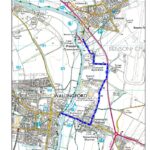
The Environment Agency has deemed the bridge to be unsafe and is therefore closed for the foreseeable future. Follow path to Bisham Abbey and then minor roads to Marlow. Note: If there are no signposts to the footpath, it's the first public footpath to the right before the (closed) bridge. Then take a left. Another option is to cross the river at Hambledon Lock and follow footpaths through Medmenham and Harleyford. Click on the map to take you to a review of this path. A boat (Brian Ferry) operates on Wednesday, Saturday and Sunday from where the diversion starts and will take you across to the lock and back.
-
 Maidenhead 121 miles
A tree has fallen between Maidenhead and Bray Lock. If you're agile you should be able to get over it. Otherwise turn left at the end of River Road and follow the footpath through a couple of fields (an equestrian centre) before joining Amerden Lane . Walk down Amerden lane following the direction of the river, turning right towards Bray Lock at the sharp bend on Amerden Lane (just before the campsite… which isn’t obvious! UPDATE 2/7: Tree has been cleared.
-
 Runnymede Pleasure Grounds 134 miles
There is a small diversion as you arrive at the Runnymede Pleasure Grounds close to the Queen Elizabeth statue. You are diverted around a compound housing standing machinery which is being used for works on Bell Weir lock. Keep the compound on you left and you will soon be back by the river.
-
 Runnymede Bridge 135 miles
Damage to a bridge has caused a diversion from just past the Runnymede Hotel to shortly before Staines. The diversion uses the A308 (pavements) returning the walker to the riverbank just before the bridge at Staines. The diversion takes about 0.6 miles of the route with minimal added distance. The diversion was expected to last 6 months from February 2024 but has been extended and could be there until 2027. The signage for this diversion has improved but is less obvious walking upstream. Take a path to your right just before the M25 bridge. This leads out to the Egham roundabout. Walk to the roundabout and take a left to the underpass. Follow the A308 until you reach Homebase. Turn left down the road which leads you back to the river. Upstream walkers: watch out for the diversion sign and turn left at the retail park (Halfords and Homebase). If you miss it you might end up walking a half mile to the bridge to find you have to walk a half mile back!
-
 Penton Hook Island 138 miles
No access to the island due to diseased trees. Thames Path unaffected.
-
 Brentford 156 miles
If taking the left bank through Brentford you will find the Path blocked on the left bank of the Grand Union Canal (between the bridge over the River Brent and Brentford Marina). There's no official diversion in place. This area is being redeveloped and so disruption should be expected for quite some time. It might be best to avoid the walk along the canal completely and follow Brentord High Street instead. Update: Parts of the route are now open. It's possible to walk down The Ham, cross the canal, follow the canal to Thames Lock, cross back over the canal at the Lock and follow Dock Road back to the High Street. Turn right on the High Street and turn down Pump Alley (ignoring the TP signs taking you down Timber Wharf Walk). This will lead you to the marina and the river.
