walk the Thames Path

Walk

THE THAMES

£0.00 0 Basket
walk the Thames Path
logo walk the thames

Walk

THE THAMES

£0.00 0 Basket
logo walk the thames

Walk

THE THAMES

£0.00 0 Basket
logo walk the thames
  • Walk the Thames Path
  • About
    • The Thames Path
    • The River Thames
    • About Us
    • Work with Us
  • Services
    • What We Do
    • Packages
      • Source to Oxford – Easy
      • Source to Oxford – Moderate
      • Oxford to Reading – Easy
      • Oxford to Reading – Moderate
      • Reading to Staines – Easy
      • Reading to Staines – Moderate
      • Staines to Woolwich – Easy
      • Staines to Woolwich – Moderate
      • Oxford to Windsor – Easy
      • Source to Woolwich – Easy
      • Source to Woolwich – Budget Option for Solo Walkers
    • Baggage Service
    • Thames Path Passport
    • Online Events
  • Plan
    • Planning your Thames Path walk
      • When to Go
      • How Long to Take
      • How to Get There
    • Route Planner
    • Map (topological)
    • Distances
    • Suggested Itineraries
    • Suggested Detours
    • Events
    • Further Resources
  • Shop
  • News
    • Route Alerts
    • Weather
    • Newsletters
    • Other blogs
      • About The Thames Path
      • Suggested detours
      • About Walk The Thames
      • Architecture and History
      • Arts and Entertainment
      • Nature
      • Sport and Leisure
      • Transport
  • Other walks
    • Camino Ingles
    • Chiltern Ramble: Deep Woods & Rolling Hills
    • Kennet & Avon Canal Walk
    • The Ridgeway
  • Contact

How to Use the Map Route Planner

How to Use the Map

Most importantly, this is not a map in the traditional sense. Do not use it to follow the Path. You must use an Ordnance Survey map for that. This is a topological representation of what you will find on the route. It has been prepared to assist you in planning your itinerary: so that you know how far you will be walking, where you can get refreshments (be it shops, cafes), where you can stay at night, transport to and from the route and places of interest that you may want to detour to.

Why Topological?

A topological map is a type of diagram that has been simplified so that only vital information remains and unnecessary detail has been removed. These maps may lack scale, distance and direction but the relationship between points is maintained.

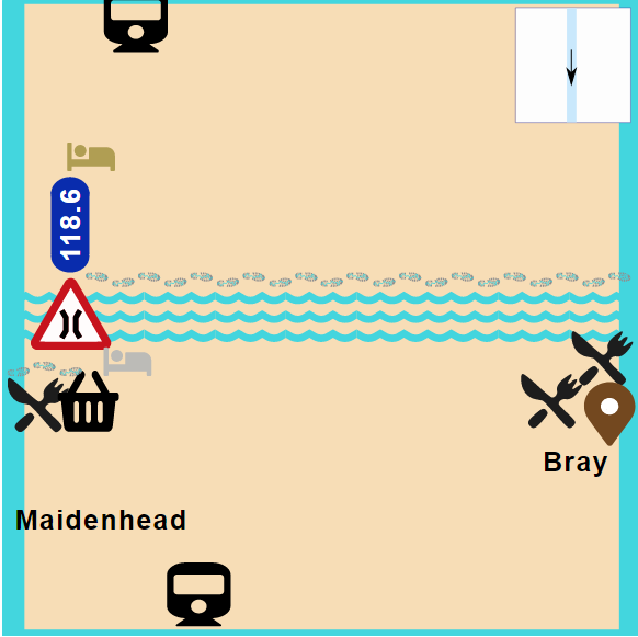
The Thames flows broadly in a direction from West to East, or left to right. It was therefore logical to arrange pages in a swipe left and right mode, even when the river turns north or south. We have stretched out the Thames in a straight line running left to right. By making the map topological, we are able to remove items that are irrelevant for Thames Path walkers (such as railway bridges that a pedestrian cannot use).

Scale and Positioning

Each page on the map is 1.25 miles by 1.25 miles (2km by 2km) with the river running through the centre. It means that the distance from the river to the top and bottom of the map is always 0.6 miles (1km). We chose this as we thought that is probably the maximum distance anyone would want to deviate from the route.

All objects shown on the map are approximately correct in respect to distance from the river. However, where objects clash we have shown the objects as they relate to each other. Thus, a street with a shop, a restaurant, a pub and a hotel would show as a strip and some points would not be completely accurate.

We have also shown some items that are important enough to be included but are not within 0.6 miles of the river. These are shown on the top and bottom edges of the map. Wherever they have been “squeezed in”, we have shown how far they are from the river. If no mention of distance is made, then the distance is accurate.

Obviously the Thames does not flow in a straight west-east line. So we have included a diagram of the approximate direction of the Thames in the top right hand corner.

Navigating between the pages

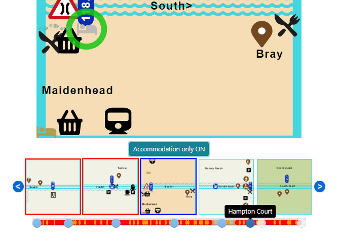
You can scroll to the left and right by clicking on the blue edge of the map. You can also go to another page by clicking on any of the 5 tiles below. The middle tile should be the map you are currently on. The tiles to the left are upstream; the tiles to the right are downstream.  Tiles with a red outline indicate that there is no accommodation available or the tile is out of range from the walking distance you have set.

Below the main map is a button which allows you to filter on only those pages with accommodation. When the filter is set, the tiles below are also filtered. 

You will also see a slider at the foot of the page. This allows you to navigate quickly between any of the pages on the map. The slider does not show when the accommodation filter is set.

Distances

Distances are shown cumulatively in miles from the source. This is calculated based on the Thames Path and not the river. To convert to Km multiply by 1.6. They are shown at key “break points” (villages, bridges, locks etc). On the page title at the top, you will also see the cumulative distance of that page. Both the distance from source and distance from mouth are shown. Distance from source is on the left; distance from mouth is on the right.

When you select accommodation it will tell you the exact distance from your last stop.

Paths and Bridges

The approximate route of the Thames Path is shown in relation to the river (which is shown as a straight line). Where, in London, the Path can be walked on either side, two paths are shown. Footpaths leading off the Path are also shown.

All river crossings available to walkers are shown. These can either be over a footbridge, a road bridge or a tunnel. Bridges that cannot carry pedestrians (some railway bridges and motorway bridges for example) are not shown as they are not relevant.

Accommodation

We have only included accommodation that is available through our packages.  

Refreshments (cafes, restaurants, pubs and shops)

The Thames Path can go from “feast to famine” and back in a short distance. Sometimes there are no facilities. Then suddenly there are lots.

Where facilities are limited i.e. in rural areas, we have shown all potential refreshment stops. Where facilities are plentiful (such as in towns), we have shown a selection of what is available. This reflects the purpose of the map: which is to help plan your itinerary. Therefore, you need to know where you can stop for food.

In central London, we have decided not to show any places of refreshment as there are so many available

Transport (Rail, Bus, Boat, Parking)

The most reliable, simple and integrated form of transport is rail. We have therefore shown all stations on or near the Path with a brief explanation of times and directions of trains together with a link to some diagrams we have put together on rail and bus routes on the Thames. Although we have shown bus routes, these are only in place where a rail service is absent.

There are a number of boat services up and down the river, some for leisure and some for commuters. These are also included.

We have not shown any car parks downstream of Hampton Court as the Path is well served by public transport.

Points of Interest

We have categorised points of interest into paid and unpaid. Some of the free attractions do require payment for viewing special exhibitions. Some of the paid attractions can be admired from outside without having to pay anything. 

Feedback

Your feedback is most valuable, whether they be errors that you have picked up, (there will be some!) or suggestions for improvement. Use the form below to help us improve.

Share this:

  • Click to share on Facebook (Opens in new window) Facebook
  • Click to share on X (Opens in new window) X

Like this:

Like Loading...

Create your walking holiday itinerary by booking hotels, transport and events throughout your Thames Path walking holiday.

We do not charge for using the route planner. And, to maintain our impartiality, we do not take any paid advertising from hotels or other establishments marked on the planner. If you feel the planner has been of benefit to you and you would like to contribute to the maintenance and further development of the system, you can contribute here.

Navigation

  • Home
  • Packages
  • Passport
  • Route Planner
  • Baggage Service
  • About Us
  • Contact
Facebook-f Instagram X-twitter

Newsletter

Worldpay

Payment currencies accepted: GBP(£)

© 2025 All rights reserved​

Terms & Conditions

Privacy Policy

Web design and SEO Reading

We use cookies on our website to give you the most relevant experience by remembering your preferences and repeat visits. By clicking “Accept All”, you consent to the use of ALL the cookies. However, you may visit "Cookie Settings" to provide a controlled consent.
Cookie SettingsAccept All
Manage consent

Privacy Overview

This website uses cookies to improve your experience while you navigate through the website. Out of these, the cookies that are categorized as necessary are stored on your browser as they are essential for the working of basic functionalities of the website. We also use third-party cookies that help us analyze and understand how you use this website. These cookies will be stored in your browser only with your consent. You also have the option to opt-out of these cookies. But opting out of some of these cookies may affect your browsing experience.
Necessary
Always Enabled
Necessary cookies are absolutely essential for the website to function properly. These cookies ensure basic functionalities and security features of the website, anonymously.
CookieDurationDescription
cookielawinfo-checkbox-analytics11 monthsThis cookie is set by GDPR Cookie Consent plugin. The cookie is used to store the user consent for the cookies in the category "Analytics".
cookielawinfo-checkbox-functional11 monthsThe cookie is set by GDPR cookie consent to record the user consent for the cookies in the category "Functional".
cookielawinfo-checkbox-necessary11 monthsThis cookie is set by GDPR Cookie Consent plugin. The cookies is used to store the user consent for the cookies in the category "Necessary".
cookielawinfo-checkbox-others11 monthsThis cookie is set by GDPR Cookie Consent plugin. The cookie is used to store the user consent for the cookies in the category "Other.
cookielawinfo-checkbox-performance11 monthsThis cookie is set by GDPR Cookie Consent plugin. The cookie is used to store the user consent for the cookies in the category "Performance".
viewed_cookie_policy11 monthsThe cookie is set by the GDPR Cookie Consent plugin and is used to store whether or not user has consented to the use of cookies. It does not store any personal data.
Functional
Functional cookies help to perform certain functionalities like sharing the content of the website on social media platforms, collect feedbacks, and other third-party features.
Performance
Performance cookies are used to understand and analyze the key performance indexes of the website which helps in delivering a better user experience for the visitors.
Analytics
Analytical cookies are used to understand how visitors interact with the website. These cookies help provide information on metrics the number of visitors, bounce rate, traffic source, etc.
Advertisement
Advertisement cookies are used to provide visitors with relevant ads and marketing campaigns. These cookies track visitors across websites and collect information to provide customized ads.
Others
Other uncategorized cookies are those that are being analyzed and have not been classified into a category as yet.
SAVE & ACCEPT
%d